Exploring the Parish of Burton upon Stather, Normanby & Thealby
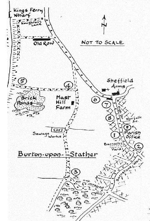
Explore the local area by following one of these maps.
Brickponds Walk - 1.75 miles (2.82 km)
- From the Parish Office, cross the High Street. Walking south, note the plaque on the end wall of the two old, white cottages near no. 43 High Street. This marks the entrance to the Barracks Yard, used by Royalist troops during the Civil War in 1643.
- Turn right at Barnston Way and continue to the junction with Flixborough Wood and Wood Hill. Turn right down this hill, which gradually becomes steeper. In Spring, a strong smell of wood garlic and the sound of bird song will reach you. Look out for red campion and yellow archangel.
- Cross the stile on your right and walk diagonally across the field, where horses graze until you come to the next stile. Turn right after crossing this, past Mast Hill Farm. Look out for cowslips, in Spring, in the adjacent fields. Watch out for long-tailed tits, yellow hammers and rabbits.
- Take the track which leads off to the left and head for the River Trent. Here you may see lilac and yellow scabious, remnants from the gardens of houses which stood near the brickworks. Bricks, tiles and land-drains were once made here and shipped out to other ports. The brickyards closed in the 1950's and have since been used by fishing clubs. Look out for reed and sedge warblers, reed buntings and tufted ducks, particularly in Spring. The first swallows of the season are often seen here.
- There is a river bank path to Flixborough to your left. Keeping right, head towards Old Row, built at the turn of the 20th Century for workers in the shipyard. Many boats were built here. Turn right at Old Row, or further on at Houghton's Lane (the choice is yours). Houghton's Lane runs next to King's Ferry Wharf from where a busy shipping company operates.
- Walk back up Stather Road hill to the Lych Gate of St Andrew's Church. This lych gate was built in 1910, in memory of Laura Sophia Sheffield who died 3rd December 1898.
- Turning right, cross Stather Road. No. 5, the 'Old House', is a Grade II listed building, the origins of which are 17th Century or earlier.
- Continue along the High Street, through the conservation area. Note No. 23, also a Grade II listed building. Although dated 1818, this is the date when a new frontage was built. The main structure is 18th Century, with earlier origins.
Fishing
In the late 19th Century, a company called 'The Burton Stather Fishing Co. Ltd' existed. The share certificate indicated that the directors were local people and it can be assumed that fish were plentiful in the River Trent at that time.
King's Ferry Wharf
The ancient ferry, plying form the Stather to Garthorpe, was part of the route used by King's Messengers, who had to be given passage across the river on demand. This busy ferry also carried passengers and was used for the carriage of sheep bound for Wakefield Market.
The River Trent
The river was used during the last war, for the training of tank crews in the use of secret tanks. Developed as amphibious craft, when these tanks were in use, local residents were not allowed out of their houses. The tanks were eventually used for the Rhine Crossing in 1945. Stather Hill was completely camouflaged as part of a war exercise. A Bailey Bridge was erected over the river and convoys of vehicles were sent across.
Pinfold, Burton
This was on Stather Road, the site now occupied by the house 'Hillcross'. Here also was sited the village pump, known as Town's Well

